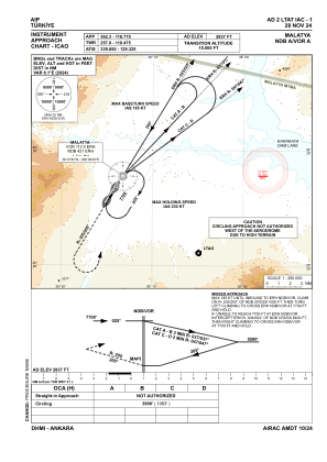
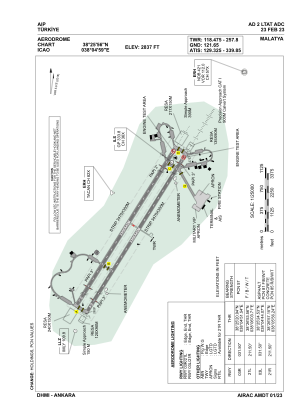


LTAT - Malatya
Located in Malatya, Turkey
ICAO - LTAT, IATA - MLX
Data provided by AirmateGeneral information
Coordinates: N38°25'56" E38°4'59"
Elevation is 2837 feet MSL.
Magnetic variation is 5.6° East View others Airports in Malatya
Operational data
Special qualification required
Current time UTC:
Current local time:
Communications frequencies: [VIEW]
Runways:
| RWY identifier | QFU | Length (ft) | Width (ft) | Surface | LDA (ft) |
| 03L | 32° | 10991 | 148 | CONC+ASPH | 10991 |
| 21R | 212° | 10991 | 148 | CONC+ASPH | 10991 |
| 03R | 32° | 10991 | 148 | ASPH | 10991 |
| 21L | 212° | 10991 | 148 | ASPH | 10991 |
Airport contact information
Address: Malatya Turkey