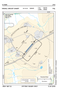
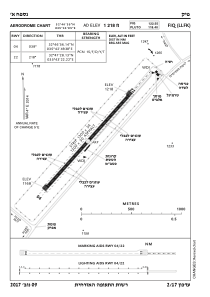


LLFK - Fik Airstrip
Located in Afik, Israel
ICAO - LLFK, IATA -
Data provided by AirmateGeneral information
Coordinates: N32°47'11" E35°43'2"
Elevation is 1218 feet MSL.
Magnetic variation is 5° East View others Airports in North District
Operational data
Special qualification required
Current time UTC:
Current local time:
Communications frequencies: [VIEW]
Runways:
| RWY identifier | QFU | Length (ft) | Width (ft) | Surface | LDA (ft) |
| 04 | 41° | 4259 | 112 | ASPH | |
| 22 | 221° | 4259 | 112 | ASPH |
Airport contact information
Address: Afik Israel