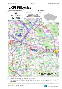
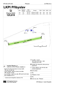


LKPI - Pribyslav
Located in Pribyslav, Czech Republic
ICAO - LKPI, IATA -
Data provided by AirmateGeneral information
Coordinates: N49°34'51" E15°45'46"
Elevation is 1742 feet MSL.
View others Airports in Vysocina Region
Operational data
Special qualification required
Current time UTC:
Current local time:
Weather at : LKPD - Pardubice ( 48 km )
METAR: LKPD 032030Z 00000KT CAVOK 13/12 Q1014 NOSIG RMK BLU BLU
TAF: TAF LKPD 031700Z 0318/0418 27005KT 9999 SCT030 TEMPO 0400/0406 6000 BKN015 PROB30 TEMPO 0402/0405 3000 MIFG BR BKN008 BECMG 0407/0409 SCT020 BECMG 0412/0414 CAVOK PROB30 TEMPO 0416/0418 09012G24KT 5000 TSRA SCT030CB
Communications frequencies: [VIEW]
Runways:
| RWY identifier | QFU | Length (ft) | Width (ft) | Surface | LDA (ft) |
| 08 | 0° | 2510 | 98 | UNK | |
| 26 | 0° | 2510 | 98 | UNK |
Airport contact information
Address: Pribyslav Czech Republic