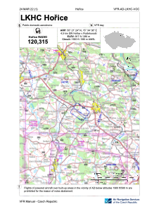
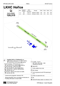


LKHC - Horice
Located in Horice V Podkrkonosi, Czech Republic
ICAO - LKHC, IATA -
Data provided by AirmateGeneral information
Coordinates: N50°21'24" E15°34'38"
Elevation is 917 feet MSL.
View others Airports in Hradec Králové Region
Operational data
Special qualification required
Current time UTC:
Current local time:
Weather at : LKPD - Pardubice ( 40 km )
METAR: LKPD 270630Z 09006KT CAVOK 10/05 Q1013 NOSIG RMK BLU BLU
TAF: TAF LKPD 270500Z 2706/2806 11004KT CAVOK BECMG 2709/2712 14012KT BECMG 2716/2718 12008KT
Communications frequencies: [VIEW]
Runways:
| RWY identifier | QFU | Length (ft) | Width (ft) | Surface | LDA (ft) |
| 12 | 0° | 2428 | 75 | GRASS | |
| 30 | 0° | 2428 | 75 | GRASS |
Airport contact information
Address: Horice V Podkrkonosi Czech Republic
