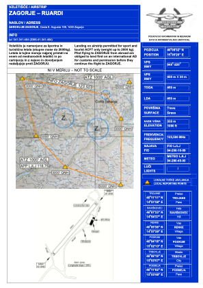


LJZAG - Zagorje-Ruardi
Located in Selo pri Zagorju, Slovenia
ICAO - , IATA -
Data provided by AirmateGeneral information
Coordinates: N46°8'32" E15°0'20"
Elevation is 1090 feet MSL.
Magnetic variation is 4° East View others Airports in Prebold
Operational data
Special qualification required
Current time UTC:
Current local time:
Weather at : LJLJ - Ljubljana/Brnik ( 43 km )
METAR: LJLJ 280600Z 34001KT 9999 BKN050 BKN250 08/07 Q1020 NOSIG
TAF: TAF LJLJ 280500Z 2806/2906 VRB02KT 9999 FEW050 TEMPO 2812/2817 25010KT
Communications frequencies: [VIEW]
Runways:
| RWY identifier | QFU | Length (ft) | Width (ft) | Surface | LDA (ft) |
| 04 | 40° | 1361 | 57 | GRAS | |
| 22 | 220° | 1361 | 57 | GRAS |
Airport contact information
Address: Selo pri Zagorju Slovenia