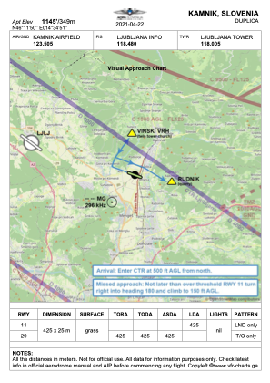


LJKAM - Kamnik
Located in Podgorje, Slovenia
ICAO - , IATA -
Data provided by AirmateGeneral information
Coordinates: N46°11'50" E14°34'51"
Elevation is 1145 feet MSL.
Magnetic variation is 4° East View others Airports in Kamnik
Operational data
Special qualification required
Current time UTC:
Current local time:
Weather at : LJLJ - Ljubljana/Brnik ( 10 km )
METAR: LJLJ 261330Z 32006KT 280V350 9999 FEW047 BKN065TCU SCT075 14/04 Q1011 NOSIG
TAF: TAF LJLJ 261100Z 2612/2712 VRB02KT 9999 FEW020 SCT040 PROB40 TEMPO 2613/2616 SHRA SCT033TCU BKN040 PROB40 2701/2706 0400 FG VV002 PROB40 TEMPO 2709/2712 SHRA BKN035TCU
Communications frequencies: [VIEW]
Runways:
| RWY identifier | QFU | Length (ft) | Width (ft) | Surface | LDA (ft) |
| 29 | 292° | 1394 | 82 | GRAS | |
| 11 | 112° | 1394 | 82 | GRAS | 1394 |
Airport contact information
Address: Podgorje Slovenia