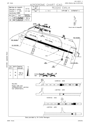


LIDE - Reggio Emilia
Located in Reggio Emilia, Italy
ICAO - LIDE, IATA -
Data provided by AirmateGeneral information
Coordinates: N44°41'56" E10°39'45"
Elevation is 152 feet MSL.
View others Airports in Emilia-Romagna
Operational data
Special qualification required
Current time UTC:
Current local time:
Weather at : LIMP - Parma ( 32 km )
METAR: LIMP 070950Z 10005KT 9999 SCT010 16/13 Q1013
TAF: TAF LIMP 070500Z 0706/0806 VRB05KT 9999 SCT010 BKN060 TEMPO 0706/0718 4000 TSRA BKN010 BKN060 BECMG 0708/0710 10010KT BECMG 0719/0721 VRB05KT TEMPO 0800/0806 2000 -RA BR BKN006
Communications frequencies: [VIEW]
Runways:
| RWY identifier | QFU | Length (ft) | Width (ft) | Surface | LDA (ft) |
| 11 | 110° | 3970 | 98 | ASP | |
| 29 | 290° | 3970 | 98 | ASP |
Airport contact information
Address: Reggio Emilia Italy
