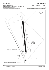


LHVE - Veresegyhaz
Located in Veresegyhaza, Hungary
ICAO - , IATA -
Data provided by AirmateGeneral information
Coordinates: N47°38'18" E19°15'23"
Elevation is 616 feet MSL.
View others Airports in Pest
Operational data
Special qualification required
Current time UTC:
Current local time:
Weather at : LHBP - Budapest/Liszt Ferenc International Airport ( 22 km )
METAR: LHBP 261400Z 15009KT 9999 VCSH FEW055TCU SCT058 BKN093 15/03 Q1012 TEMPO -SHRA SCT040TCU BKN055
TAF: TAF LHBP 261115Z 2612/2712 15008KT CAVOK TEMPO 2612/2617 VRB12G22KT -SHRA SCT035TCU BKN060 BECMG 2616/2619 10005KT TEMPO 2620/2706 VRB03KT BECMG 2708/2711 16009KT
Communications frequencies: [VIEW]
Runways:
| RWY identifier | QFU | Length (ft) | Width (ft) | Surface | LDA (ft) |
| 08 | 0° | 1673 | 66 | GRASS | |
| 26 | 0° | 1673 | 66 | GRASS |
Airport contact information
Address: Veresegyhaza Hungary