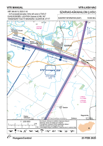


LHSV - Szarvas/Kakahalom
Located in Szarvas, Hungary
ICAO - , IATA -
Data provided by AirmateGeneral information
Coordinates: N46°48'14" E20°31'40"
Elevation is 272 feet MSL.
View others Airports in Békés
Operational data
Special qualification required
Current time UTC:
Current local time:
Weather at : LHSN - Szolnok ( 42 km )
METAR: LHSN 260445Z 00000KT 6000 MIFG FEW002 03/03 Q1012 NOSIG RMK WHT
TAF: TAF LHSN 260515Z 2606/2615 VRB02KT CAVOK TEMPO 2608/2612 16005KT 9999 FEW040
Communications frequencies: [VIEW]
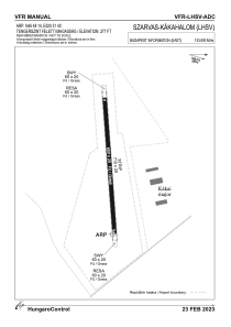
Runways:
| RWY identifier | QFU | Length (ft) | Width (ft) | Surface | LDA (ft) |
| 09 | 0° | 2133 | 262 | GRASS | |
| 27 | 0° | 2133 | 262 | GRASS |
Airport contact information
Address: Szarvas Hungary