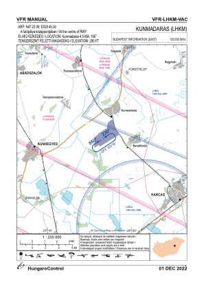
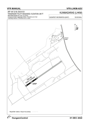


LHKM - Kunmadaras
Located in Kunmadaras, Hungary
ICAO - , IATA -
Data provided by AirmateGeneral information
Coordinates: N47°23'9" E20°46'26"
Elevation is 290 feet MSL.
View others Airports in Jász-Nagykun-Szolnok
Operational data
Special qualification required
Current time UTC:
Current local time:
Weather at : LHSN - Szolnok ( 50 km )
METAR: LHSN 021915Z VRB01KT CAVOK 17/11 Q1009 NOSIG RMK BLU
TAF: TAF LHSN 021715Z 0218/0303 25008KT CAVOK BECMG 0218/0220 13005KT TEMPO 0218/0224 VRB03KT PROB30 TEMPO 0223/0303 VRB12G22KT 8000 SHRA SCT033TCU BKN060 BECMG 0301/0303 07007KT
Communications frequencies: [VIEW]
Runways:
| RWY identifier | QFU | Length (ft) | Width (ft) | Surface | LDA (ft) |
| 05 | 0° | 2297 | 197 | CONC | |
| 23 | 0° | 2297 | 197 | CONC |
Airport contact information
Address: Kunmadaras Hungary