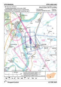
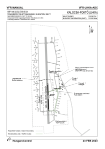


LHKA - Kalocsa-Fokto
Located in Kalocsa, Hungary
ICAO - , IATA -
Data provided by AirmateGeneral information
Coordinates: N46°32'52" E18°56'34"
Elevation is 299 feet MSL.
View others Airports in Bács-Kiskun
Operational data
Special qualification required
Current time UTC:
Current local time:
Weather at : LHKE - Kecskemet ( 74 km )
METAR: LHKE 020245Z 11010KT 080V140 CAVOK 15/07 Q1012 NOSIG RMK BLU
TAF: TAF LHKE 020215Z 0203/0212 12010KT CAVOK BECMG 0205/0207 14013KT TEMPO 0207/0212 15015G25KT 9999 SCT040 BKN070
Communications frequencies: [VIEW]
Runways:
| RWY identifier | QFU | Length (ft) | Width (ft) | Surface | LDA (ft) |
| 17 | 0° | 2608 | 82 | CONC | |
| 35 | 0° | 2608 | 82 | CONC |
Airport contact information
Address: Kalocsa Hungary