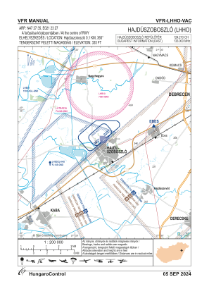
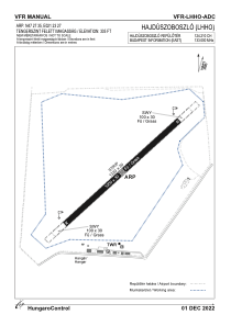


LHHO - Hajduszoboszlo
Located in Hajduszoboszlo, Hungary
ICAO - LHHO, IATA -
Data provided by AirmateGeneral information
Coordinates: N47°27'21" E21°23'27"
Elevation is 335 feet MSL.
View others Airports in Hajdu-Bihar
Operational data
Special qualification required
Current time UTC:
Current local time:
Weather at : LHDC - Debrecen International Airport ( 17 km )
TAF: TAF LHDC 282015Z 2821/2906 08005KT CAVOK TEMPO 2900/2906 VRB03KT
Communications frequencies: [VIEW]
Runways:
| RWY identifier | QFU | Length (ft) | Width (ft) | Surface | LDA (ft) |
| 04 | 0° | 3281 | 98 | GRASS | |
| 22 | 0° | 3281 | 98 | GRASS |
Airport contact information
Address: Hajduszoboszlo Hungary