


LHDK - Dunakeszi
Located in Dunakeszi, Hungary
ICAO - LHDK, IATA -
Data provided by AirmateGeneral information
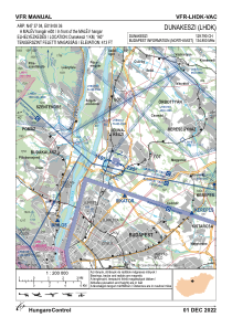
Coordinates: N47°37'4" E19°8'36"
Elevation is 413 feet MSL.
Magnetic variation is 3.8° East View others Airports in Pest
Operational data
Special qualification required
Current time UTC:
Current local time:
Weather at : LHBP - Budapest/Liszt Ferenc International Airport ( 22 km )
METAR: LHBP 301800Z 09004KT CAVOK 19/06 Q1020 NOSIG
TAF: TAF LHBP 301715Z 3018/0118 09006KT CAVOK BECMG 0107/0110 12011KT
Communications frequencies: [VIEW]
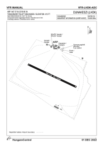
Runways:
| RWY identifier | QFU | Length (ft) | Width (ft) | Surface | LDA (ft) |
| 11 | 0° | 2592 | 98 | GRASS | |
| 29 | 0° | 2592 | 98 | GRASS |
Airport contact information
Address: Dunakeszi Hungary