


LFSS - Saint Sulpice Des Landes
Located in Bain De Bretagne, France
ICAO - , IATA -
Data provided by AirmateGeneral information
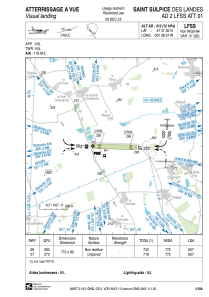
Coordinates: N47°47'30" W1°38'37"
Elevation is 312 feet MSL.
Magnetic variation is -0.14° East View others Airports in Pays-de-la-Loire
Operational data
Special qualification required
Current time UTC:
Current local time:
Weather at : LFRN - Rennes Saint Jacques ( 32 km )
TAF: TAF LFRN 070500Z 0706/0806 VRB05KT 9999 BKN008 BECMG 0708/0711 35010KT BKN020 BECMG 0722/0724 VRB05KT 3000 BR BECMG 0800/0802 0500 FG VV/// PROB40 TEMPO 0802/0806 0300 FG VV///
Communications frequencies: [VIEW]
Runways:
| RWY identifier | QFU | Length (ft) | Width (ft) | Surface | LDA (ft) |
| 09 | 92° | 2533 | 262 | GRASS | 2090 |
| 27 | 272° | 2533 | 262 | GRASS | 2156 |
Airport contact information
Address: Bain De Bretagne France
