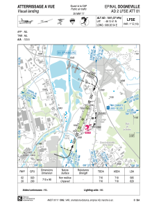


LFSE - Epinal Dogneville
Located in Epinal, France
ICAO - LFSE, IATA -
Data provided by AirmateGeneral information
Coordinates: N48°12'41" E6°26'54"
Elevation is 1041 feet MSL.
Magnetic variation is 2.21° East View others Airports in Lorraine
Operational data
Special qualification required
Current time UTC:
Current local time:
Weather at : LFSG - Epinal Mirecourt ( 31 km )
METAR: LFSG 262100Z AUTO VRB02KT CAVOK 06/05 Q1006
Communications frequencies: [VIEW]
Runways:
| RWY identifier | QFU | Length (ft) | Width (ft) | Surface | LDA (ft) |
| 02 | 20° | 2329 | 295 | GRASS | |
| 20 | 200° | 2329 | 295 | GRASS |
Airport contact information
Address: Epinal France

