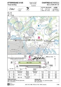


LFOR - Chartres Metropole
Located in Chartres, France
ICAO - LFOR, IATA - QTJ
Data provided by AirmateGeneral information
Coordinates: N48°27'32" E1°31'26"
Elevation is 509 feet MSL.
Magnetic variation is 0.79° East View others Airports in Centre
Operational data
Special qualification required
Current time UTC:
Current local time:
Communications frequencies: [VIEW]
Runways:
| RWY identifier | QFU | Length (ft) | Width (ft) | Surface | LDA (ft) |
| 09L | 93° | 2953 | 328 | GRASS | 2953 |
| 27R | 273° | 2953 | 328 | GRASS | 2953 |
| 09 | 93° | 2756 | 82 | ASPH | 840 |
| 27 | 273° | 2756 | 82 | ASPH | 2756 |
Airport contact information
Address: Chartres France


