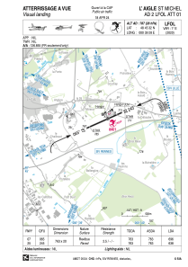


LFOL - L'aigle Saint Michel
Located in L'aigle, France
ICAO - LFOL, IATA -
Data provided by AirmateGeneral information
Coordinates: N48°45'32" E0°39'28"
Elevation is 787 feet MSL.
Magnetic variation is 0.51° East View others Airports in Lower Normandy
Operational data
Special qualification required
Current time UTC:
Current local time:
Weather at : LFOE - Evreux Fauville ( 51 km )
METAR: LFOE 292230Z AUTO 18005KT CAVOK 11/07 Q1017 NOSIG
TAF: TAF LFOE 292000Z 2921/3021 17006KT 9999 FEW040 TEMPO 3004/3007 BKN008 PROB40 TEMPO 3004/3011 4000 -RA BECMG 3007/3009 SCT008 BKN015 TEMPO 3012/3017 17010G20KT 4000 -SHRA BKN015 BKN020CB BECMG 3017/3019 CAVOK
Communications frequencies: [VIEW]
Runways:
| RWY identifier | QFU | Length (ft) | Width (ft) | Surface | LDA (ft) |
| 07 | 66° | 2503 | 66 | ASPH | 2283 |
| 25 | 246° | 2503 | 66 | ASPH | 2093 |
Airport contact information
Address: L'aigle France
Other aviation service providers
Aviation club (not for profit)

Amicale des Pilotes de l'Aigle St Michel
Amicale des Pilotes de l'Aigle St Michel
jeanfrancois.roy@free.fr+33233242152