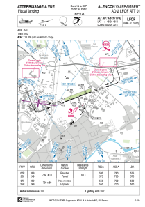


LFOF - Alencon Valframbert
Located in Alencon, France
ICAO - LFOF, IATA - XAN
Data provided by AirmateGeneral information
Coordinates: N48°26'48" E0°6'30"
Elevation is 476 feet MSL.
Magnetic variation is 0.36° East View others Airports in Lower Normandy
Operational data
Special qualification required
Current time UTC:
Current local time:
Communications frequencies: [VIEW]
Runways:
| RWY identifier | QFU | Length (ft) | Width (ft) | Surface | LDA (ft) |
| 07L | 69° | 2395 | 262 | GRASS | 1804 |
| 25R | 249° | 2395 | 262 | GRASS | 1804 |
| 07R | 69° | 2559 | 59 | ASPH | 1886 |
| 25L | 249° | 2559 | 59 | ASPH | 1952 |
Airport contact information
Address: Alencon France
Other aviation service providers
Aviation club (not for profit)

Aéroclub d'Alençon et sa Région
Aéroclub d'Alençon et sa Région
contact@aeroclub-alencon.org+33233292586
Association de Voltige Alençonnaise
Association de Voltige Alençonnaise
alainodolant@sfr.fr+33233276183