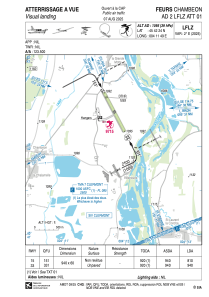


LFLZ - Feurs Chambeon
Located in Feurs, France
ICAO - LFLZ, IATA -
Data provided by AirmateGeneral information
Coordinates: N45°42'24" E4°11'49"
Elevation is 1095 feet MSL.
Magnetic variation is 1.65° East View others Airports in Rhône Alpes
Operational data
Special qualification required
Current time UTC:
Current local time:
Weather at : LFMH - Saint Etienne Loire ( 21 km )
METAR: LFMH 260400Z AUTO 17004KT 140V200 9999 -RA FEW044/// OVC050/// ///TCU 08/05 Q1005
Communications frequencies: [VIEW]
Runways:
| RWY identifier | QFU | Length (ft) | Width (ft) | Surface | LDA (ft) |
| 15 | 153° | 3084 | 197 | GRASS | |
| 33 | 333° | 3084 | 197 | GRASS |
Airport contact information
Address: Feurs France

