


LFHY - Moulins Montbeugny
Located in Moulins, France
ICAO - LFHY, IATA - XMU
Data provided by AirmateGeneral information
Coordinates: N46°32'4" E3°25'18"
Elevation is 915 feet MSL.
Magnetic variation is 1.43° East View others Airports in Auvergne
Operational data
Special qualification required
Current time UTC:
Current local time:
Weather at : LFLV - Vichy Charmeil ( 40 km )
METAR: LFLV 260730Z AUTO 16003KT 120V200 9999 FEW007 OVC035 10/08 Q1006
Communications frequencies: [VIEW]
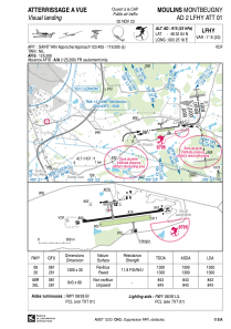
Runways:
| RWY identifier | QFU | Length (ft) | Width (ft) | Surface | LDA (ft) |
| 08R | 82° | 2766 | 262 | GRASS | 2766 |
| 26L | 262° | 2766 | 262 | GRASS | 2766 |
| 08 | 82° | 4265 | 98 | ASPH | 4265 |
| 26 | 262° | 4265 | 98 | ASPH | 4265 |
Airport contact information
Address: Moulins France


