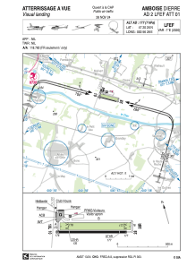


LFEF - Amboise Dierre
Located in Amboise, France
ICAO - LFEF, IATA - XAM
Data provided by AirmateGeneral information
Coordinates: N47°20'26" E0°56'28"
Elevation is 177 feet MSL.
Magnetic variation is 0.68° East View others Airports in Centre
Operational data
Special qualification required
Current time UTC:
Current local time:
Weather at : LFOT - Tours Val De Loire ( 19 km )
METAR: LFOT 300900Z AUTO 14005KT 9999 FEW012 BKN030 OVC056 14/12 Q1013 NOSIG
TAF: TAF LFOT 300500Z 3006/0106 15005KT CAVOK TEMPO 3006/3009 -RA PROB40 TEMPO 3006/3009 -RA BKN012 PROB30 TEMPO 3006/3008 3500 -RA BKN006 PROB30 TEMPO 3012/3016 21010KT -SHRA SCT030 TEMPO 3023/0106 4000 BR PROB30 TEMPO 0104/0106 2500 -RA BKN004
Communications frequencies: [VIEW]
Runways:
| RWY identifier | QFU | Length (ft) | Width (ft) | Surface | LDA (ft) |
| 10L | 105° | 2297 | 197 | GRASS | 1991 |
| 28R | 285° | 2297 | 197 | GRASS | 2096 |
| 10 | 105° | 2297 | 82 | ASPH | 1870 |
| 28 | 285° | 2297 | 82 | ASPH | 2057 |
Airport contact information
Address: Amboise France

