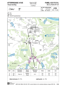


LFDX - Fumel Montayral
Located in Fumel, France
ICAO - LFDX, IATA -
Data provided by AirmateGeneral information
Coordinates: N44°27'33" E1°0'26"
Elevation is 692 feet MSL.
Magnetic variation is 0.84° East View others Airports in Aquitaine
Operational data
Special qualification required
Current time UTC:
Current local time:
Communications frequencies: [VIEW]
Runways:
| RWY identifier | QFU | Length (ft) | Width (ft) | Surface | LDA (ft) |
| 17 | 171° | 2329 | 59 | ASPH | 2329 |
| 35 | 351° | 2329 | 59 | ASPH | 2329 |
Airport contact information
Address: Fumel France
