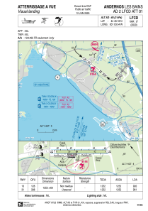


LFCD - Andernos Les Bains
Located in Andernos, France
ICAO - LFCD, IATA -
Data provided by AirmateGeneral information
Coordinates: N44°45'18" W1°3'54"
Elevation is 64 feet MSL.
Magnetic variation is 0.24° East View others Airports in Aquitaine
Operational data
Special qualification required
Current time UTC:
Current local time:
Weather at : LFBC - Cazaux ( 25 km )
METAR: LFBC 260230Z AUTO 21003KT 9999 FEW010 BKN056 BKN074 10/09 Q1005
TAF: TAF LFBC 252000Z 2521/2621 24005KT 9999 SCT020 BKN060 TEMPO 2521/2610 4000 SHRA SCT010 BKN015TCU
Communications frequencies: [VIEW]
Runways:
| RWY identifier | QFU | Length (ft) | Width (ft) | Surface | LDA (ft) |
| 13 | 128° | 4068 | 197 | GRASS | 2986 |
| 31 | 308° | 4068 | 197 | GRASS | 3150 |
Airport contact information
Address: Andernos France
Fuel provider

Other aviation service providers
Aviation club (not for profit)

HELI'S COOL Héliclub du Bassin d'Arcachon
HELI'S COOL Héliclub du Bassin d'Arcachon
info@heliscool.fr+33608714287
