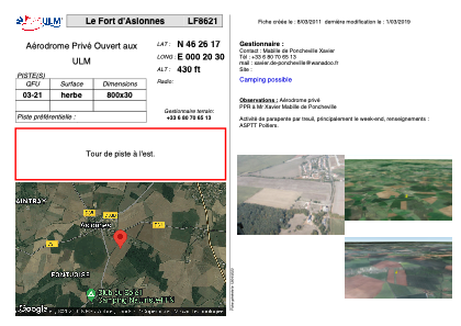


LF8621 - Le Fort d'Aslonnes
Located in Aslonnes , France
ICAO - , IATA -
Data provided by AirmateGeneral information
Coordinates: N46°26'17" E0°20'30"
Elevation is 430 feet MSL.
View others Airports in Poitou-Charentes
Operational data
Special qualification required
Current time UTC:
Current local time:
Weather at : LFBI - Poitiers Biard ( 17 km )
METAR: LFBI 280330Z AUTO 24009KT CAVOK 08/07 Q1006 TEMPO BKN005
TAF: TAF AMD LFBI 280131Z 2801/2824 19012KT CAVOK TEMPO 2801/2804 4000 SHRA BKN012 BKN025TCU TEMPO 2804/2807 BKN005 TEMPO 2809/2818 -SHRA BKN020CB PROB30 TEMPO 2810/2815 TSRA
Communications frequencies: [VIEW]
Runways:
| RWY identifier | QFU | Length (ft) | Width (ft) | Surface | LDA (ft) |
| 03 | 0° | 2624 | 98 | GRASS | |
| 21 | 0° | 2624 | 98 | GRASS |
Airport contact information
Address: Aslonnes France