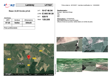


LF7027 - Lambrey
Located in Lambrey, France
ICAO - , IATA -
Data provided by AirmateGeneral information
Coordinates: N47°46'4" E5°56'20"
Elevation is 820 feet MSL.
View others Airports in Franche-Comté
Operational data
Special qualification required
Current time UTC:
Current local time:
Weather at : LFSX - Luxeuil Saint Sauveur ( 32 km )
METAR: LFSX 261130Z AUTO 19009KT 150V210 9999 BKN024/// BKN042/// BKN048/// ///CB 12/07 Q1006
TAF: TAF LFSX 260800Z 2609/2709 20010KT 9999 OVC025 TEMPO 2609/2611 4900 -RA OVC010 TEMPO 2609/2620 4500 SHRA BKN015TCU PROB40 TEMPO 2609/2619 4000 -TSRA BKN010CB PROB30 TEMPO 2611/2618 2000 TSRAGS BKN010CB
Communications frequencies: [VIEW]
Runways:
| RWY identifier | QFU | Length (ft) | Width (ft) | Surface | LDA (ft) |
| 07 | 0° | 1082 | 82 | GRASS | |
| 25 | 0° | 1082 | 82 | GRASS |
Airport contact information
Address: Lambrey France