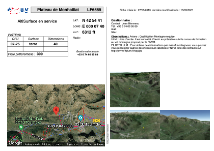


LF6555 - Plateau de Monhaillat
Located in Sers, France
ICAO - , IATA -
Data provided by AirmateGeneral information
Coordinates: N42°54'41" E0°7'40"
Elevation is 6312 feet MSL.
View others Airports in Midi-Pyrénées
Operational data
Special qualification required
Current time UTC:
Current local time:
Weather at : LFBT - Tarbes Lourdes Pyrenees ( 32 km )
METAR: LFBT 260630Z AUTO 16004KT CAVOK 08/07 Q1006 NOSIG
TAF: TAF LFBT 260500Z 2606/2706 VRB03KT 9999 SCT020 BKN060 BECMG 2612/2614 SCT040 FEW050CB BKN140 PROB40 TEMPO 2614/2620 4000 SHRA BECMG 2620/2622 FEW025 BKN090 PROB40 TEMPO 2701/2706 4000 BR PROB30 TEMPO 2702/2705 0800 FG
Communications frequencies: [VIEW]
Runways:
| RWY identifier | QFU | Length (ft) | Width (ft) | Surface | LDA (ft) |
| 07 | 0° | 131 | 0 | DIRT | |
| 25 | 0° | 131 | 0 | DIRT |
Airport contact information
Address: Sers France