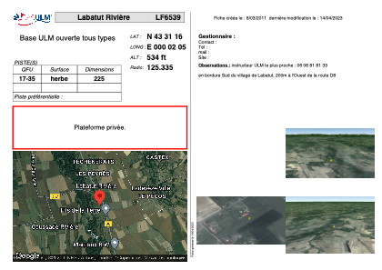


LF6539 - Labatut Rivière
Located in Labatut-Rivière, France
ICAO - , IATA -
Data provided by AirmateGeneral information
Coordinates: N43°31'16" E0°2'5"
Elevation is 534 feet MSL.
View others Airports in Midi-Pyrénées
Operational data
Special qualification required
Current time UTC:
Current local time:
Weather at : LFBT - Tarbes Lourdes Pyrenees ( 37 km )
METAR: LFBT 081630Z AUTO 02006KT 330V050 9999 FEW045 19/11 Q1024 NOSIG
TAF: TAF LFBT 081100Z 0812/0912 02005KT 9999 SCT025 BECMG 0813/0815 CAVOK BECMG 0818/0820 VRB03KT PROB30 TEMPO 0901/0906 4000 BR BECMG 0907/0909 07007KT
Communications frequencies: [VIEW]
Runways:
| RWY identifier | QFU | Length (ft) | Width (ft) | Surface | LDA (ft) |
| 17 | 0° | 738 | 0 | GRASS | |
| 35 | 0° | 738 | 0 | GRASS |
Airport contact information
Address: Labatut-Rivière France