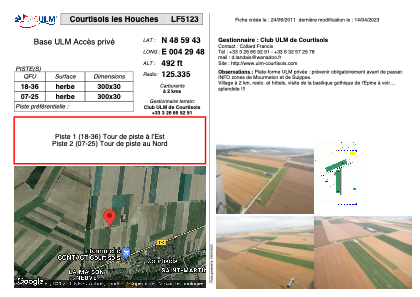


LF5123 - Courtisols les Houches
Located in Courtisols, France
ICAO - , IATA -
Data provided by AirmateGeneral information
Coordinates: N48°59'43" E4°29'48"
Elevation is 492 feet MSL.
View others Airports in Champagne-Ardenne
Operational data
Special qualification required
Current time UTC:
Current local time:
Weather at : LFOK - Chalons Vatry ( 33 km )
METAR: LFOK 270500Z AUTO 16009KT 9999 -DZ FEW027 BKN086 OVC100 08/07 Q1004 TEMPO 4000 SHRA SCT014 BKN025CB
TAF: TAF LFOK 262300Z 2700/2724 17008KT CAVOK PROB40 TEMPO 2700/2714 4000 SHRA SCT014 BKN025CB TEMPO 2714/2724 15015G28KT
Communications frequencies: [VIEW]
Runways:
| RWY identifier | QFU | Length (ft) | Width (ft) | Surface | LDA (ft) |
| 18 | 0° | 984 | 98 | GRASS | |
| 36 | 0° | 984 | 98 | GRASS |
Airport contact information
Address: Courtisols France