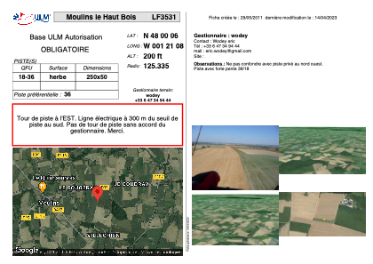


LF3531 - Moulins le Haut Bois
Located in Moulins, France
ICAO - , IATA -
Data provided by AirmateGeneral information
Coordinates: N48°0'6" W1°21'8"
Elevation is 200 feet MSL.
View others Airports in Brittany
Operational data
Special qualification required
Current time UTC:
Current local time:
Weather at : LFRN - Rennes Saint Jacques ( 29 km )
METAR: LFRN 041530Z AUTO 13010KT 100V160 9999 BKN013 BKN019 OVC035 12/10 Q1008 TEMPO 2000 BR BKN003
TAF: TAF LFRN 041100Z 0412/0512 13010KT 9999 BKN030 PROB40 TEMPO 0412/0415 4000 RA BKN008 BECMG 0415/0417 OVC008 TEMPO 0417/0424 3000 RADZ BKN008 BECMG 0416/0418 VRB05KT PROB40 TEMPO 0417/0422 2000 BR BKN003 BECMG 0421/0424 22010KT BECMG 0500/0502 BKN020 BECMG 0502/0504 VRB05KT TEMPO 0502/0509 BKN008 BECMG 0508/0510 18010KT TEMPO 0509/0512 3000 RA BKN015CB PROB30 TEMPO 0510/0512 2000 TSRA
Communications frequencies: [VIEW]
Runways:
| RWY identifier | QFU | Length (ft) | Width (ft) | Surface | LDA (ft) |
| 18 | 0° | 820 | 164 | GRASS | |
| 36 | 0° | 820 | 164 | GRASS |
Airport contact information
Address: Moulins France