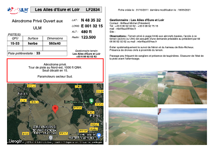


LF2834 - Les Ailes d'Eure et Loir
Located in Pierres, France
ICAO - , IATA -
Data provided by AirmateGeneral information
Coordinates: N48°35'32" E1°32'15"
Elevation is 480 feet MSL.
View others Airports in Centre
Operational data
Special qualification required
Current time UTC:
Current local time:
Communications frequencies: [VIEW]
Runways:
| RWY identifier | QFU | Length (ft) | Width (ft) | Surface | LDA (ft) |
| 15 | 0° | 1837 | 131 | GRASS | |
| 33 | 0° | 1837 | 131 | GRASS |
Airport contact information
Address: Pierres France