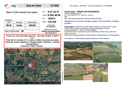


LF1826 - Sury en Vaux
Located in Sury-en-Vaux, France
ICAO - , IATA -
Data provided by AirmateGeneral information
Coordinates: N47°22'51" E2°46'58"
Elevation is 1000 feet MSL.
View others Airports in Burgundy
Operational data
Special qualification required
Current time UTC:
Current local time:
Weather at : LFOA - Avord ( 38 km )
METAR: LFOA 051600Z AUTO 07003KT 9999 -RA FEW012/// SCT070/// OVC082/// ///CB 16/15 Q1008
TAF: TAF AMD LFOA 050525Z 0505/0603 24005KT 9999 BKN019 OVC032 TX19/0515Z TN12/0603Z TEMPO 0505/0511 BKN008 PROB30 TEMPO 0505/0509 3000 DZ BKN006 TEMPO 0511/0520 VRB10G20KT 4000 SHRA BKN020CB PROB30 TEMPO 0514/0520 30015G40KT 2000 TSRA TEMPO 0601/0603 4000 RA BKN008 OVC050
Communications frequencies: [VIEW]
Runways:
| RWY identifier | QFU | Length (ft) | Width (ft) | Surface | LDA (ft) |
| 08 | 0° | 984 | 65 | GRASS | |
| 26 | 0° | 984 | 65 | GRASS |
Airport contact information
Address: Sury-en-Vaux France