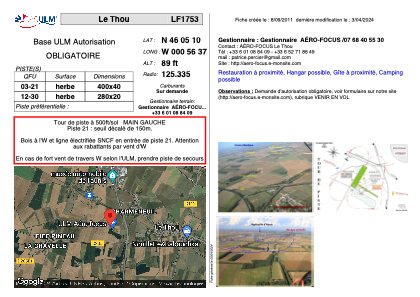


LF1753 - Le Thou
Located in Le Thou, France
ICAO - , IATA -
Data provided by AirmateGeneral information
Coordinates: N46°5'10" W0°56'37"
Elevation is 89 feet MSL.
View others Airports in Pays-de-la-Loire
Operational data
Special qualification required
Current time UTC:
Current local time:
Weather at : LFBH - La Rochelle Ile De Re ( 22 km )
METAR: LFBH 070730Z AUTO 34011KT 9999 BKN008 OVC012 13/12 Q1018 BECMG SCT008
TAF: TAF LFBH 070500Z 0706/0806 29016KT 9999 BKN011 OVC060 TEMPO 0706/0708 4500 -SHRA BKN008 SCT020TCU BECMG 0708/0710 35010KT SCT008 BECMG 0711/0713 29012KT PROB30 TEMPO 0711/0716 4500 -SHRA SCT025TCU BECMG 0715/0717 01008KT
Communications frequencies: [VIEW]
Runways:
| RWY identifier | QFU | Length (ft) | Width (ft) | Surface | LDA (ft) |
| 03 | 0° | 1312 | 131 | GRASS | |
| 21 | 0° | 1312 | 131 | GRASS |
Airport contact information
Address: Le Thou France