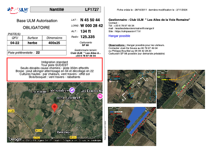


LF1727 - Nantillé
Located in Nantillé, France
ICAO - , IATA -
Data provided by AirmateGeneral information
Coordinates: N45°50'44" W0°28'42"
Elevation is 134 feet MSL.
View others Airports in Poitou-Charentes
Operational data
Special qualification required
Current time UTC:
Current local time:
Weather at : LFBG - Cognac Chateaubernard ( 24 km )
METAR: LFBG 260700Z AUTO 18006KT 9999 BKN008 BKN056 11/09 Q1005 TEMPO 4500 -SHRA BKN014TCU
TAF: TAF AMD LFBG 260536Z 2605/2703 21007KT 9999 BKN025 OVC060 PROB40 TEMPO 2606/2612 4500 -SHRA BKN014TCU TEMPO 2612/2617 22015G25KT 3000 -TSRA BKN020CB PROB30 TEMPO 2617/2703 4000 -SHRA BKN030CB
Communications frequencies: [VIEW]
Runways:
| RWY identifier | QFU | Length (ft) | Width (ft) | Surface | LDA (ft) |
| 04 | 0° | 1312 | 82 | GRASS | |
| 22 | 0° | 1312 | 82 | GRASS |
Airport contact information
Address: Nantillé France