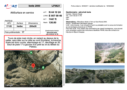


LF0621 - Isola 2000
Located in Saint-Sauveur-de-Tinée, France
ICAO - , IATA -
Data provided by AirmateGeneral information
Coordinates: N44°10'24" E7°9'46"
Elevation is 7447 feet MSL.
View others Airports in Provence-Alpes-Côte-d'Azur
Operational data
Special qualification required
Current time UTC:
Current local time:
Weather at : LIMZ - Cuneo/Levaldigi ( 55 km )
METAR: LIMZ 021220Z 34007KT 310V010 9999 FEW005 BKN025 13/13 Q1003
TAF: TAF LIMZ 021100Z 0212/0312 34010KT 8000 BKN015 TEMPO 0212/0217 4000 TSRA BECMG 0218/0220 VRB05KT
Communications frequencies: [VIEW]
Runways:
| RWY identifier | QFU | Length (ft) | Width (ft) | Surface | LDA (ft) |
| 17 | 0° | 820 | 65 | GRASS | |
| 35 | 0° | 820 | 65 | GRASS |
Airport contact information
Address: Saint-Sauveur-de-Tinée France