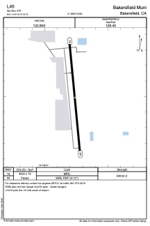


L45 - Bakersfield Muni
Located in Bakersfield, United States
ICAO - L45, IATA -
Data provided by AirmateGeneral information
Coordinates: N35°19'30" W118°59'46"
Elevation is 378 feet MSL.
Magnetic variation is 14° East View others Airports in California
Operational data
Special qualification required
Current time UTC:
Current local time:
Weather at : KBFL - Meadows Fld ( 13 km )
METAR: KBFL 300654Z AUTO 35004KT 10SM CLR 18/04 A2996 RMK AO2 SLP141 T01780044
TAF: KBFL 300520Z 3006/0106 VRB06KT P6SM SKC FM301700 31009KT P6SM SKC FM010300 VRB06KT P6SM SKC
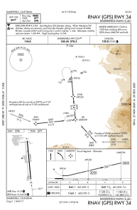
Communications frequencies: [VIEW]
Runways:
| RWY identifier | QFU | Length (ft) | Width (ft) | Surface | LDA (ft) |
| 16 | 175° | 4000 | 75 | ASPH | |
| 34 | 355° | 4000 | 75 | ASPH |
Airport contact information
Address: Bakersfield United States
