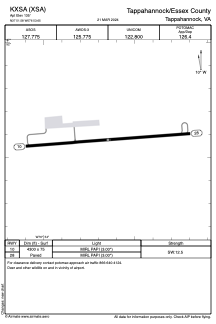


KXSA - Tappahannock/Essex County
Located in Tappahannock, United States
ICAO - XSA, IATA -
Data provided by AirmateGeneral information
Coordinates: N37°51'35" W76°53'39"
Elevation is 135 feet MSL.
Magnetic variation is -11° East View others Airports in Virginia
Operational data
Special qualification required
Current time UTC:
Current local time:
Weather
METAR: KXSA 271455Z AUTO 00000KT 10SM SCT044 OVC065 14/10 A3049 RMK AO2 T01370095
Communications frequencies: [VIEW]
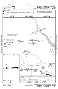
Runways:
| RWY identifier | QFU | Length (ft) | Width (ft) | Surface | LDA (ft) |
| 10 | 86° | 4300 | 75 | ASPH | |
| 28 | 266° | 4300 | 75 | ASPH |
Airport contact information
Address: Tappahannock United States