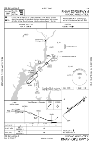
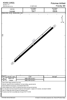


KVKX - Potomac Airfield
Located in Friendly, United States
ICAO - VKX, IATA -
Data provided by AirmateGeneral information
Coordinates: N38°44'55" W76°57'21"
Elevation is 117 feet MSL.
Magnetic variation is -11° East View others Airports in Maryland
Operational data
Special qualification required
Current time UTC:
Current local time:
Weather at : KADW - Joint Base Andrews ( 10 km )
METAR: KADW 281655Z 00000KT 10SM FEW160 FEW200 26/15 A3014 RMK AO2A SLP212 T02580149 $
TAF: TAF KADW 281700Z 2817/2923 24006KT 9999 FEW070 FEW200 QNH3003INS BECMG 2821/2822 20009KT 9999 FEW250 QNH3002INS BECMG 2903/2904 23006KT 9999 SKC QNH2999INS BECMG 2910/2911 26006KT 9999 SKC QNH2997INS BECMG 2918/2919 19006KT 9999 SCT070 QNH2994INS BECMG 2922/2923 15006KT 9999 SCT060 SCT180 QNH2993INS TX29/2821Z TN16/2911Z
Communications frequencies: [VIEW]
Runways:
| RWY identifier | QFU | Length (ft) | Width (ft) | Surface | LDA (ft) |
| 06 | 48° | 2665 | 40 | ASPH | |
| 24 | 228° | 2665 | 40 | ASPH |
Airport contact information
Address: Friendly United States

