


KTYR - Tyler Pounds Rgnl
Located in Tyler, United States
ICAO - TYR, IATA - TYR
Data provided by AirmateGeneral information
Coordinates: N32°21'13" W95°24'11"
Elevation is 544 feet MSL.
Magnetic variation is 03° East View others Airports in Texas
Operational data
Special qualification required
Current time UTC:
Current local time:
Weather
METAR: KTYR 260153Z 16013KT 10SM CLR 24/20 A2985 RMK AO2 SLP101 T02390200
TAF: KTYR 252327Z 2600/2624 16013G23KT P6SM SCT050 BKN150 BKN250 TEMPO 2606/2608 BKN025 FM260800 17013G23KT P6SM BKN015 FM261500 17017G27KT P6SM OVC015 FM261800 17018G30KT P6SM VCTS BKN030CB OVC140 FM262000 17017G30KT P6SM VCTS BKN040CB BKN140
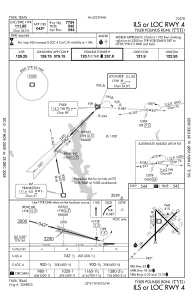
Communications frequencies: [VIEW]
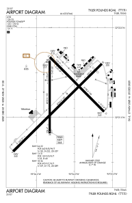
Runways:
| RWY identifier | QFU | Length (ft) | Width (ft) | Surface | LDA (ft) |
| 04 | 45° | 8334 | 150 | CONC | 7734 |
| 22 | 225° | 8334 | 150 | CONC | 7734 |
| 13 | 135° | 5198 | 150 | ASPH | 5198 |
| 31 | 315° | 5198 | 150 | ASPH | 5198 |
| 18 | 180° | 4832 | 150 | ASPH | 4832 |
| 36 | 0° | 4832 | 150 | ASPH | 4832 |
Airport contact information
Address: Tyler United States
