


KTVF - Thief River Falls Rgnl
Located in Thief River Falls, United States
ICAO - TVF, IATA - TVF
Data provided by AirmateGeneral information
Coordinates: N48°3'56" W96°11'6"
Elevation is 1118 feet MSL.
Magnetic variation is 02° East View others Airports in Minnesota
Operational data
Special qualification required
Current time UTC:
Current local time:
Weather
METAR: KTVF 080741Z AUTO 10010KT 10SM SCT010 BKN044 11/09 A2954 RMK AO2
TAF: KTVF 080520Z 0806/0906 11013KT P6SM BKN040 FM081000 09007KT P6SM BKN009 FM081700 07010KT P6SM BKN040 FM082200 06010KT P6SM VCSH BKN050 FM090200 04006KT P6SM SCT060
Communications frequencies: [VIEW]
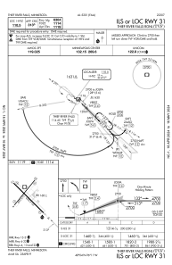
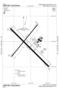
Runways:
| RWY identifier | QFU | Length (ft) | Width (ft) | Surface | LDA (ft) |
| 04 | 39° | 4997 | 75 | ASPH | 4997 |
| 22 | 219° | 4997 | 75 | ASPH | 4997 |
| 13 | 135° | 6504 | 150 | ASPH | 6504 |
| 31 | 315° | 6504 | 150 | ASPH | 6304 |
Airport contact information
Address: Thief River Falls United States