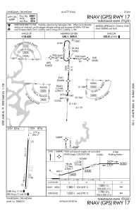


KTQH - Tahlequah Muni
Located in Tahlequah, United States
ICAO - TQH, IATA -
Data provided by AirmateGeneral information
Coordinates: N35°55'49" W95°0'16"
Elevation is 874 feet MSL.
Magnetic variation is 05° East View others Airports in Oklahoma
Operational data
Special qualification required
Current time UTC:
Current local time:
Weather
METAR: KTQH 260755Z AUTO 12013G22KT 10SM SCT033 BKN090 15/12 A2980 RMK AO2
Communications frequencies: [VIEW]
Runways:
| RWY identifier | QFU | Length (ft) | Width (ft) | Surface | LDA (ft) |
| 17 | 182° | 5001 | 75 | ASPH | |
| 35 | 2° | 5001 | 75 | ASPH |
Airport contact information
Address: Tahlequah United States