


KTPH - Tonopah
Located in Tonopah, United States
ICAO - TPH, IATA -
Data provided by AirmateGeneral information
Coordinates: N38°3'36" W117°5'12"
Elevation is 5430 feet MSL.
Magnetic variation is 15° East View others Airports in Nevada
Operational data
Special qualification required
Current time UTC:
Current local time:
Weather
METAR: KTPH 050656Z AUTO 03008KT 10SM CLR 06/M04 A2962 RMK AO2 SLP993 T00561044 $
TAF: KTPH 050520Z 0506/0606 27015G25KT P6SM BKN100 FM050900 32015G25KT P6SM OVC060 FM051200 35022G32KT P6SM BKN070 FM051500 34030G40KT P6SM BKN070 FM052000 33022G32KT P6SM BKN080 FM060300 33015G25KT P6SM SCT080
Communications frequencies: [VIEW]
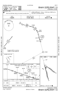
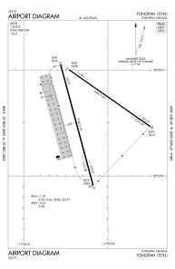
Runways:
| RWY identifier | QFU | Length (ft) | Width (ft) | Surface | LDA (ft) |
| 11 | 125° | 5660 | 50 | ASPH | |
| 29 | 305° | 5660 | 50 | ASPH | |
| 15 | 165° | 7160 | 75 | ASPH | |
| 33 | 345° | 7160 | 75 | ASPH | |
| H1 | 0° | 0 | 0 | UNK |
Airport contact information
Address: Tonopah United States