


KTNT - Dade-Collier Training And Transition
Located in Miami, United States
ICAO - TNT, IATA -
Data provided by AirmateGeneral information
Coordinates: N25°51'43" W80°53'49"
Elevation is 12 feet MSL.
Magnetic variation is -05° East View others Airports in Florida
Operational data
Special qualification required
Current time UTC:
Current local time:
Weather at : KTMB - Miami Exec ( 52 km )
METAR: KTMB 271853Z 09018G28KT 10SM SCT036 27/18 A3014 RMK AO2 PK WND 09030/1818 SLP205 T02720183
TAF: KTMB 271946Z 2720/2818 09015G25KT P6SM SCT025 BKN050 FM280900 09011G20KT P6SM SCT025 BKN050 FM281400 10015G25KT P6SM SCT025 BKN050
Communications frequencies: [VIEW]
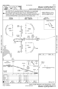
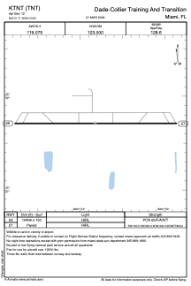
Runways:
| RWY identifier | QFU | Length (ft) | Width (ft) | Surface | LDA (ft) |
| 09 | 90° | 10499 | 150 | ASPH | |
| 27 | 270° | 10499 | 150 | ASPH |
Airport contact information
Address: Miami United States