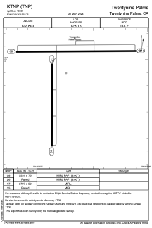


KTNP - Twentynine Palms
Located in Twentynine Palms, United States
ICAO - TNP, IATA -
Data provided by AirmateGeneral information
Coordinates: N34°7'54" W115°56'45"
Elevation is 1888 feet MSL.
Magnetic variation is 12° East View others Airports in California
Operational data
Special qualification required
Current time UTC:
Current local time:
Weather at : KNXP - Twentynine Palms Self ( 27 km )
TAF: TAF KNXP 0815/0915 33012KT 9999 SKC QNH2987INS FM081600 34020G30KT 9999 SKC QNH2982INS BECMG 0820/0822 34013KT 9999 SKC QNH2972INS FM090200 33007KT 9999 SKC QNH2975INS FM090400 30006KT 9999 SKC QNH2980INS T26/0823Z T12/0913Z
Communications frequencies: [VIEW]
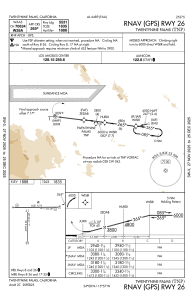
Runways:
| RWY identifier | QFU | Length (ft) | Width (ft) | Surface | LDA (ft) |
| 08 | 90° | 5531 | 75 | ASPH | |
| 26 | 270° | 5531 | 75 | ASPH | |
| 17 | 180° | 3797 | 50 | ASPH | |
| 35 | 0° | 3797 | 50 | ASPH |
Airport contact information
Address: Twentynine Palms United States