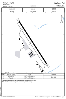


KTLR - Mefford Fld
Located in Tulare, United States
ICAO - TLR, IATA -
Data provided by AirmateGeneral information
Coordinates: N36°9'24" W119°19'36"
Elevation is 265 feet MSL.
Magnetic variation is 12° East View others Airports in California
Operational data
Special qualification required
Current time UTC:
Current local time:
Weather at : KVIS - Visalia Muni ( 19 km )
METAR: KVIS 300256Z AUTO 30009KT 10SM CLR 22/05 A2992 RMK AO2 SLP140 T02170050 53002
TAF: KVIS 292320Z 3000/3024 31012G20KT P6SM SKC FM300300 31009KT P6SM SKC FM300600 VRB06KT P6SM SKC FM301800 31008KT P6SM SKC
Communications frequencies: [VIEW]
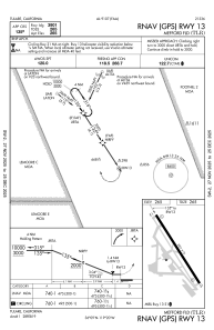
Runways:
| RWY identifier | QFU | Length (ft) | Width (ft) | Surface | LDA (ft) |
| 13 | 147° | 3901 | 75 | ASPH | |
| 31 | 327° | 3901 | 75 | ASPH |
Airport contact information
Address: Tulare United States