


KTLH - Tallahassee Intl
Located in Tallahassee, United States
ICAO - TLH, IATA - TLH
Data provided by AirmateGeneral information
Coordinates: N30°23'48" W84°21'3"
Elevation is 83 feet MSL.
Magnetic variation is -05° East View others Airports in Florida
Operational data
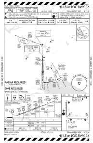
Special qualification required
Current time UTC:
Current local time:
Weather
METAR: KTLH 280753Z AUTO 09008KT 10SM OVC036 20/17 A3017 RMK AO2 SLP216 T02000167
TAF: KTLH 280520Z 2806/2906 09007KT P6SM SCT120 FM281500 12010G15KT P6SM FEW040 SCT100 FM282100 15007KT P6SM SCT050
Communications frequencies: [VIEW]
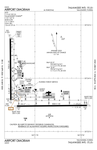
Runways:
| RWY identifier | QFU | Length (ft) | Width (ft) | Surface | LDA (ft) |
| 09 | 89° | 8000 | 150 | ASPH | |
| 27 | 269° | 8000 | 150 | ASPH | |
| 18 | 179° | 7000 | 150 | ASPH | |
| 36 | 359° | 7000 | 150 | ASPH |
Airport contact information
Address: Tallahassee United States
