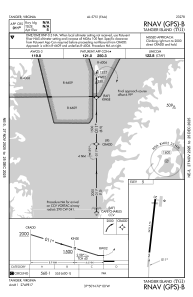
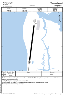


KTGI - Tangier Island
Located in Tangier, United States
ICAO - TGI, IATA -
Data provided by AirmateGeneral information
Coordinates: N37°49'33" W75°59'52"
Elevation is 5 feet MSL.
Magnetic variation is -11° East View others Airports in Virginia
Operational data
Special qualification required
Current time UTC:
Current local time:
Weather
METAR: KTGI 272015Z AUTO 12009KT 10SM OVC070 15/08 A3042 RMK AO1 T01500080
Communications frequencies: [VIEW]
Runways:
| RWY identifier | QFU | Length (ft) | Width (ft) | Surface | LDA (ft) |
| 02 | 7° | 2426 | 75 | ASPH | |
| 20 | 187° | 2426 | 75 | ASPH |
Airport contact information
Address: Tangier United States