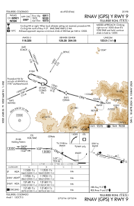
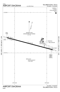


KTEX - Telluride Rgnl
Located in Telluride, United States
ICAO - TEX, IATA - TEX
Data provided by AirmateGeneral information
Coordinates: N37°57'14" W107°54'32"
Elevation is 9069 feet MSL.
Magnetic variation is 09° East View others Airports in Colorado
Operational data
Special qualification required
Current time UTC:
Current local time:
Weather
METAR: KTEX 031355Z AUTO 15003KT 10SM OVC090 06/M14 A3010 RMK AO2
TAF: KTEX 031120Z 0312/0412 28004KT P6SM FEW250 FM031400 19008KT P6SM FEW200 FM031700 23017G31KT P6SM FEW080 FM032000 25018G32KT P6SM FEW080 FM040200 19009KT P6SM FEW070
Communications frequencies: [VIEW]
Runways:
| RWY identifier | QFU | Length (ft) | Width (ft) | Surface | LDA (ft) |
| 09 | 105° | 7111 | 100 | ASPH | 6911 |
| 27 | 285° | 7111 | 100 | ASPH | 6911 |
Airport contact information
Address: Telluride United States