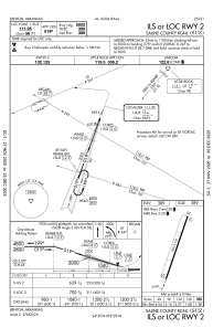
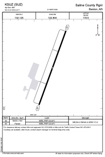


KSUZ - Saline County Rgnl
Located in Benton, United States
ICAO - SUZ, IATA -
Data provided by AirmateGeneral information
Coordinates: N34°35'25" W92°28'46"
Elevation is 389 feet MSL.
Magnetic variation is 01° East View others Airports in Arkansas
Operational data
Special qualification required
Current time UTC:
Current local time:
Weather at : KLIT - Bill And Hillary Clinton Ntl/Adams Fld ( 28 km )
METAR: KLIT 282353Z 12003KT 10SM FEW031 FEW110 23/19 A2990 RMK AO2 RAB12E33 TSB16E35 SLP126 TS MOV NE E P0000 60000 T02330194 10244 20206 56009
TAF: KLIT 282323Z 2900/2924 18007KT P6SM VCTS SCT060CB BKN120 FM290600 14010KT 5SM -SHRA BR OVC015 TEMPO 2906/2910 VRB15G25KT 3SM -TSRA BR OVC010CB FM291000 14003KT 5SM -SHRA BR OVC007 FM291800 13008KT P6SM BKN050 FM292200 35004KT P6SM BKN100
Communications frequencies: [VIEW]
Runways:
| RWY identifier | QFU | Length (ft) | Width (ft) | Surface | LDA (ft) |
| 02 | 20° | 5002 | 100 | ASPH | |
| 20 | 200° | 5002 | 100 | ASPH |
Airport contact information
Address: Benton United States
Other aviation service providers
Repair station

Flight schools

Central Arkansas Flying Club
Central Arkansas Flying Club
centralarkansasflyinclub@yahoo.com+1(501)776-7212