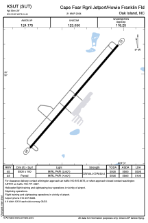


KSUT - Cape Fear Rgnl Jetport/Howie Franklin Fld
Located in Oak Island, United States
ICAO - SUT, IATA -
Data provided by AirmateGeneral information
Coordinates: N33°55'51" W78°4'24"
Elevation is 26 feet MSL.
Magnetic variation is -08° East View others Airports in North Carolina
Operational data
Special qualification required
Current time UTC:
Current local time:
Weather
METAR: KSUT 261310Z AUTO 04006KT 10SM OVC008 15/12 A3030 RMK AO2 T01450117
Communications frequencies: [VIEW]
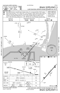
Runways:
| RWY identifier | QFU | Length (ft) | Width (ft) | Surface | LDA (ft) |
| 05 | 41° | 5505 | 100 | ASPH | 5505 |
| 23 | 221° | 5505 | 100 | ASPH | 5105 |
Airport contact information
Address: Oak Island United States
