


KSSF - Stinson Muni
Located in San Antonio, United States
ICAO - SSF, IATA -
Data provided by AirmateGeneral information
Coordinates: N29°20'13" W98°28'16"
Elevation is 577 feet MSL.
Magnetic variation is 08° East View others Airports in Texas
Operational data
Special qualification required
Current time UTC:
Current local time:
Weather
METAR: KSSF 300153Z 13013KT 10SM SCT100 25/19 A2984 RMK AO2 PK WND 11027/0058 SLP092 T02500194 $
TAF: KSSF 292352Z 3000/3024 12009KT P6SM FEW060 TEMPO 3000/3002 12012G22KT FM300700 12005KT P6SM BKN013 FM301000 14005KT 4SM BR BKN008 FM301500 14008KT P6SM BKN015 FM301800 14010KT P6SM SCT040
Communications frequencies: [VIEW]
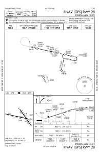
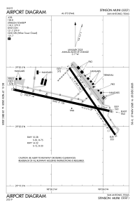
Runways:
| RWY identifier | QFU | Length (ft) | Width (ft) | Surface | LDA (ft) |
| 09 | 103° | 5000 | 100 | ASPH | |
| 27 | 283° | 5000 | 100 | ASPH | |
| 14 | 145° | 4128 | 100 | ASPH | |
| 32 | 325° | 4128 | 100 | ASPH |
Airport contact information
Address: San Antonio United States
